Monday, May 30, 2016

Redmond to Harrisburg OR

Today's drive was from Redmond to Harrisburg OR.  We've done it before, but we were a little soft on the details, so I'm documenting for the next time.  This will be a boring post.
But first, here are the Sisters.  They used to be called Faith, Hope and Charity.  Now they're known as North, South and Middle.


The most direct route is via US20. However, the Tombstone summit is east of Sweet Home.  The Mountain Directory West guide tells us that there is an eleven mile stretch of 6% descent.  The grade is steady with 25, 30 and 35 mph curves, on a narrow two lane road.  After the eleven miles, the grade eases to 3% for many miles.  There are signs telling drivers that vehicles over 50 feet should not take US20, and they're right.  US20 is the middle gray line.
The bottom gray line goes over McKenzie pass which is barely passable by automobile.
Thus, we went US20 and then north on OR22, which is the blue line.  


It's a beautiful drive.  One of the things we always forget is how much descending there is.  After you go over Santiam, there is a lot of downhill.  Between Santiam and the eventual on ramp to I5, 4,000 feet of elevation is lost.  US20 and OR22 have some pretty good descents, only Santiam is signed.  Once you reach OR226 it becomes more of a rolling grade, but the trend is still downhill. Please make a note of this.


The route turns south onto OR226 in Mehama and continues through Lyons.  It then goes to Scio and makes another south.   Both GPS units were trying to take us down tiny little farm roads after Lyons.  Scio!  The turn is in Scio!


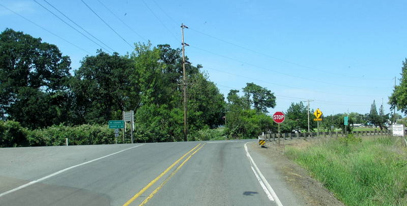
Eventually OR226 will rejoin US20 at this intersection.  Go right!


US20 runs into I5. After that, it's easy driving.

Despite the holiday, traffic was not horrible.  We were on the road by 8 am, and getting through Sisters (a small tourist filled village) was not bad at all.  On the two lane roads, traffic in front of us was very light.  Getting up early was a good thing.  Every NFS campground we saw was full to the gills.  If they all left at the same time, traffic was going to be bad.

We're here for the week getting things fixed at Erik's, and having fluids changed at Cummins NW in Coburg.  It will be a long four days and may not generate anything interesting enough to write about.  There are few things as tedious and being in the shop with one's home.

Sunday, May 29, 2016

Pleasant Walking and Miscellaneous Stuff

This morning we drove out to the Eagle Crest Resort.  If you drive to the back of the resort there is some parking and a path down to a river trail.  It's really very pleasant down there next to the water.  The resort itself is unbelievably big, with a massive golf course.  There are asphalt paths running everywhere; today they were packed with families on bicycles.  Very few people were on the river trail.  If you want a pleasant, unpopulated aspect, this is the place.


Yesterday, after leaving the museum, we stopped at Safeway and got a sandwich.  We were parked next to a hill which was full of what we think are California ground squirrels.  The entire hill side was full of burrows.  This is a family.  The adult was standing guard, while the juveniles were milling around.


The adult sent the kids back to the burrow so he (or she) could roll in the dirt.  I love watching squirrels.  I realize people who have had them in their attics are not fond of them, but so far we've had no issues with them.


This is such an interesting trailer.  It has a pop top. There's a sink drain going into the sewer, so I doubt if there are holding tanks.  We did not see any identifying marks on it, so I have no idea what it is.


This is one of the reasons we consider the driver's side of an RV site toxic.  When our neighbor left, first they took the sewer hose off with bare hands.  Then they completed emptying it onto the ground. Following that, they took the clear plastic elbow off and placed it on the power pedestal.  Prior to leaving they picked it up bare handed and stowed it.  They then jumped in their truck and drove away.  I think a quick over view of microbiology and sterile technique should be required of all RV owners.


Tomorrow (!) we're leaving for Harrisburg.  We've got the truck hooked to the RV already and we'll be getting up really early.  Hopefully traffic will not be too horrific.  As a rule we don't travel on Memorial Day, but we're currently schedule driven, and so we must go.

Saturday, May 28, 2016

Erickson Air Museum

Today we went out to Madras to visit the Erickson Air Museum.  It's not the largest collection we've visited, but it's particularly cool in that all the planes with the exception of two are airworthy.

The Grumman J2F Duck was first delivered to the USN fleet in 1934 to perform utility duties aboard aircraft carriers and to provide a ship-shore link. It served the military for over seventeen years and was also employed by the Coast Guard in its search and rescue role.  This is one of the last flyable Ducks in the world.


It's leaking.  Almost all of the planes are leaking.  Jim says if a piston engine airplane is not leaking then it's out of oil.


A B17G which was a Pathfinder during WWII.  Using ground mapping radar, they led the bomber formations to their assigned targets.  This is the only remaining Pathfinder B17.


This is the bomb bay of the B17.  Their bomb bays were not very large.  The Americans believed in day time precision bombing, and carried more crew and more defensive weapons.  There were machine guns pointing everywhere.  The British Lancaster, on the other hand, bombed at night, bombed large areas and carried more bombs.  They had a smaller crew and fewer defensive weapons.  

This is the dreaded ventral ball turret.  There was no room for a parachute.  He had to be cranked up and in to a position that would allow him to exit the turret.  The plane could land with the turret down, but if the landing gear collapsed, it was over for him.


This is how he spent his day.


The Bellanca Aircruiser, built in 1938.  It originally was slated to carry passengers, but regulations were put in place that required multiple engines.  Many pilots considered it to be the most efficient single engine plane ever built.  It could carry its own weight in cargo, 2,000 pounds.  This plane was in service until 1968, when it ran aground on take off with a full cargo of fish.  In 1972 it was rescued and restored to flying condition.  It was affectionately known as the Flying W.


A P-51 in the markings of the airplanes flown by the Tuskegee Airmen.  They were a segregated unit of African American pilots commanded by Captain Benjamin O. Davis, Jr.  Captain Davis was a 1936 West Point graduate where he endured four years of shunning by his white class mates.  Their job was to protect the bombers, not shoot down enemy planes.  They did not lose a single bomber. 


Behind the museum there are more planes.  This is a Lockheed P2V Neptune. It was a maritime patrol and submarine hunter in its day.  It was flown by the US Navy.  Note the two outboard jet engines which were used to assist on take off.  The plane was later replaced by the P3 Orion.


Jack Erickson also owns a flying service.  He provides sky cranes, helicopters for logging and planes for fire fighting.  This line of planes are MD-80s with their engines off.  Eventually these will all be converted to air tankers to fight forest fires.  In recent years it has become evident that we don't have enough of these planes.


I only covered three of the indoor planes, there are many more to see.  It's not just the planes, it's the history and the period of time they represent.  If you're in the Redmond/Sisters area, this is definitely worth a visit. 

Friday, May 27, 2016

Historic Redmond

Today we went back out to Smith Rock.  We were going to cross the bridge and turn left this time.  Unfortunately I forgot to bring socks.  I hate when that happens.  So we decided we would go in to the historic downtown district of Redmond and walk.
Here is the  Redmond sign and a cheerful basket of flowers.  Local business reporting is predicting another surge in population in this part of Oregon.  Bend is pretty full, so growth may be pushing north into Redmond.  It's hard to know how the current population would feel about being the "next Bend."


One of the pawnshops in the historic district. 


Suzanne of Take to the Highway saw these pants in Santa Paula, and here they are in Redmond.  We were particularly taken with the size of the skirt on the dress in the window.  That's an impressive amount of fabric.


I love this piercing place.  One the left, out of frame, there is a pirate flag.  The evil pumpkin guys is very fetching.


Here we have an excellent example of realtor speak.  "Charming historical bungalow, in an area of upscale offices and well kept homes, just blocks from restaurants and shopping."


We were laughing so hard, I forgot to get a picture of the house, but here is a blow up of the flyer.  It's just an old house on a tiny lot, and they want $249,900 for it.


Here are the "well kept homes" across the street.  If I were an out of town buyer, I would be extremely unhappy after traveling to see this vintage charmer.


We stopped in a hardware store after downtown and lunch, it's called Coastal.  They're only in Washington and Oregon.  If you see one, go in.  If they don't have it, you don't need it.  If my feet were not cursed, I'd be trying these on.  Pretty.....


They have the biggest selection of Wranglers that I have seen anywhere.  There is fishing stuff, farm stuff, clothing, hardware and etc.


Today was another really windy day.  We actually wore long pants and I had a vest on.  Cold!

Thursday, May 26, 2016

Smith Rock

Today marked the first time since November that there has been strenuous exercise.  It felt wonderful.  We went out to Smith Rock for a walk with hiking poles.  Is it not beautiful here?  To get to the trails on the other side of the water, there is a steep little descent.


Look closely and you can see the switch backs with people on them.  That's the Misery Ridge trail which we did not do today.  It climbs 900 feet in one mile.


Instead, we did the Wolf Tree trail.  It's mainly flat and goes along the Crooked River.


This is at the base of a really steep climb on a different trail.  I guess if you injure yourself, you break open the litter and crutch your way back to the trail head.


Parts of the trail remind us of Utah, only not as red.


Look in the lower right hand corner of this photo.  See the dark blob with some white around it?  That's an eagle's nest.  There are several of them up in the rocks.  After breeding season, they'll re-open the area to rock climbers.


It was a good day. 

Klamath Falls to Redmond OR

The drive to Redmond was stress free and fairly bucolic.  We went straight up 97.  There is a Pilot just north of Klamath Falls that is very easily accessed.   It's good to stop there for fuel, after you head north there are very few opportunities.

 
We're back at the Deschutes County Expo Center and RV park for the next few days.

Wednesday, May 25, 2016

Klamath Falls KOA

We stayed at the KOA while overnighting in Klamath Falls.  It's in the "Journey" category, as in it's not a destination RV park.


The park is sort of a pain to get into.  One must make a sharp right turn into the drive, and then an immediate second sharp turn in the parking lot.  It's doable, as long as no one is blocking the arc of your turn.
If someone is at the other pump, it will make the turn difficult.


Interior roads are paved, sites are gravel and fairly unlevel.  Power is good.  Water pressure is good.  Verizon is pretty dang slow, it takes awhile for Google maps to load.  They do lead you to your site, which is good.  No data on restrooms or laundry.  There are trains, with loud whistles, late at night.
We're in site 27 which is a pull through, and we have a clear shot at the southern sky.
It's ok for an overnight, and we would come back here.

Tuesday, May 24, 2016

Sparks, NV to Klamath Falls, OR

Today's route was US395, to CA139 to OR39.  See the gray line between just south of Susanville up to Adin?  That is CA139.  If you are driving a Class A,
NEVER GO THIS WAY.
The lanes are very narrow, the fog stripe is often on the crumbling edge of the road.  There are sharp drops from the edge of the road.  The surface of the road is so rough that it causes the RV to move from side to side.  It was 65 miles of absolutely miserable driving.  Jim held it to 40 - 45 to keep the bus under control.  We would have been better off staying on US395 and going through Alturas and then over to CA139.  It's longer, but the road is better and speeds would have been higher. 


The road surface on a good stretch.


There are several pretty good climbs on the route.  Here were are behind the first paint truck of the day on a climb.  The yellow center stripe was wet.  Hours later we would be behind another paint truck doing the fog stripe.


If you're in a B or a C class, or a car, or a motorcycle, it's a gorgeous drive.  It's just not enough road for a Class A.


So, we're pretty tired and happy to be in Klamath Falls.

Sparks Marina RV Park and Environs

While in Sparks, NV we stayed at the Sparks Marina RV Park.  It's an unusual park.  We can't figure out why it's there.  Sparks is one of those cities that pretty much consists of retail and traffic.  The park is groomed to within an inch of its life.
So, as we see, interior roads are paved.  Sites are concrete, and require some leveling.  Power is good.  Water pressure is good.  Verizon 4G varied from really good to really bad, frequently within a five minute period.  Over all it was usable.  There is a huge laundry, which we did not use.  No data on the restrooms.


This is one of the tightest RV parks we have ever been in.  That's our pickup parked next to our neighbor's sewer run.  We had to balance not running over the sewer hose with being able to open the driver's door.  If you don't like being close to the neighbors, you will not like this park.  Notice the green?  That's astro-turf.   We did like that, nothing to track in to the RV.


It's a nice looking park, but sites are very close together.


This is a man made lake which provides the name "Sparks Marina" to the area.  It's pretty.  There are paved walking paths, play grounds for the kids, stuff like that.


Sparks reminds me of an ant hill.  There is a lot of traffic, and people drive very fast.  However, it was a good stop for buying groceries, going to Trader Joe's and an RV supply store.

Even though Sparks is right off of I80, there's not much in the way of truck plazas.  There is a TA at exit 19.  It can only be reached from one direction of travel, there is a median on McCarran Blvd.  When you exit the freeway, you can make a right into the parking lot.  If you're going to the freeway from Sparks, there is a median, so you can't turn left.  There is a Petro farther east which we went to from the RV park using surface streets. So, if in Sparks, check the maps.

Where Sparks is new and shiny with three left turn lanes into the shopping malls, Reno is tired and sad.  I think prosperity has moved out of downtown Reno into the suburbs.  Reno is engaged in several large construction projects, but it doesn't look good.


Where is everyone?


It was a good stop.  We waited out the terrible weather farther north and went to the car museum.  I would not come back for an over night stay, I'd head up to Bordertown, north of Reno.