Sunday, August 30, 2009

Dayton, OH - Wright Patterson AFB Museum

We've spent two nights in Dayton. Sunday we went to the Air Force Museum at Wright Patterson Air Force Base. If you ever find yourself in Dayton, go here! Dress warmly, apparently the airplanes like to be kept cool, but definitely go. It's a fabulous museum.
The outside of the museum.

Wright Patterson is a huge air force base. One of the hangars has several presidential airplanes and a bunch of R&D planes. Most of them are one offs and this is the only place they can be seen.
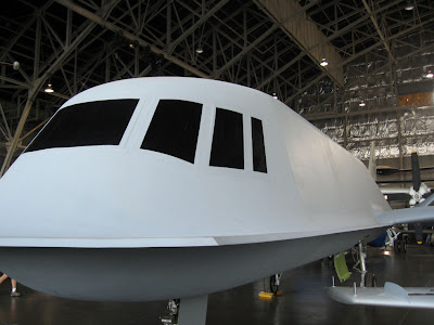
This is TACIT BLUE. It's one of the first experiments in stealth technology. It was built in 1982, and flew 135 times before being retired. It's a weird looking plane, it looks like it's made out of plywood.

The B-70 Valkyrie. The plane was designed to be bomber in the '50s. First flight was 1964, it flew 3 times the speed of sound and it is unbelievably big. Here is the nose.
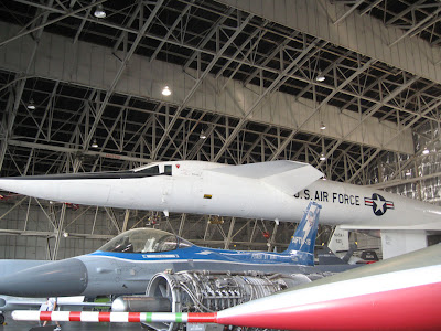

The mid-section and engines.
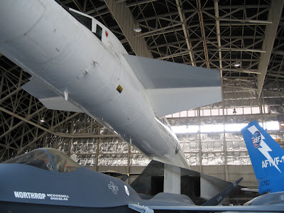
The rear end of the plane. There are six huge engines on the plane. There were two of them built, one was destroyed in an accident on a photo flight in 1966, the remaining airplane (this one) was used for research until it was delivered to the Air Force Museum. The airplane was never produced as a bomber as intended. It was eventually abandoned in favor of ICBM missiles.

This is Jim standing by the nose gear.

I forget what this is, it was some sort of trainer cockpit riveted on to a Convair 580. It looks like one plane is being eaten by another.

A lifting body experimental plane.

This is the Air Force One 707 that brought JFK's body back to Washington after his assassination in Dallas.


Now we are back in the main part of the museum, which is huge. This is an early bomber, circa WWI. Some of the bombs were flung from the plane by hand.


The original use of bungee cords. They were wrapped around the landing gear to provide shock absorption.


Note the fuel tank performing its secondary function as a back rest.


The museum has set up several displays of airplanes and told stories about their use. This is a WW II-era trainer. The poor trainee has hit the brakes too hard and has driven the nose of the plane into the ground.
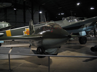
The German ME163 Komet, from WWII. It was a rocket powered airplane with 7.5 minutes of fuel. When it launched, the wheels were designed to come off so it had to be landed on a retractable belly skid. It would climb up through an American bomber formation and attempt to attack the bombers, and then when it ran out of fuel it would go back through the formation again. It had two cannons, and two opportunities to shoot at Allied planes. Think about this. Shot up into the air, run out of fuel, land on the belly. Does this sound like a plan or what? It was not extensively used during the war.

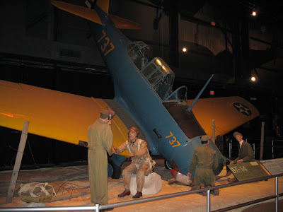
This is a tableau from Oahu, Hawaii, during the attack on Pearl Harbor. Second Lieutenant Phillip Rasmussen did indeed run out in his pajamas during the Japanese attack and get his plane airborne before it could be destroyed. He hooked up with 3 other planes and pursued the attackers.


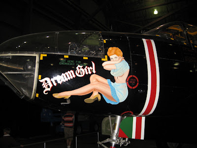
Nose art from the plane that dropped the atomic bomb on Nagasaki.


More nose art.

In addition to the planes, the museum tells a lot of stories and presents a lot of history. We were there for 6 hours and could not begin to read it all. It's an enormous place, and well worth the time to see it.

Friday, August 28, 2009

Hillsdale Michigan

We've had a stop over in Hillsdale, MI to see friends from when we all worked at Boeing. Hillsdale is the county seat and has some great old buildings. There are some gorgeous old homes within walking distance of the downtown area. Look at how pretty this house is.

Look at the chimneys. How often do you see that anymore?


We took a short walk through Hillsdale College. It's a small liberal arts college. They have a beautiful campus.


There are sculptures on the grounds of several states-people. This is Margaret Thatcher.

We also did 5 loads of laundry, massive grocery shopping and we defrosted the freezer. Why can we not have a frost free freezer in an RV?

Tuesday, August 25, 2009

Crossing the Country - Terror in the Heartland

This morning we left the Niagara Falls area of NY for Ohio. Our departure was good, all attachments to utilities were removed prior to pulling away, nothing out of the ordinary. But then we turned on the GPS for guidance to Sandusky. The directions seemed a little odd but we thought we'd trust her. After she wanted us to drive down a tiny neighborhood street, we decided she'd lost her mind again. We were able to pull into a church parking lot to assess our route. Somehow the navigator's instruction to the pilot to go south, got garbled in the universal translator and he went north. We drove and drove, looking for a place to turn around. No joy. And then we saw it, the sign that strikes terror into the heart of the RV'er. Bridge height 11 feet in 1 & 1/2 miles. We're 13+ feet. We made an immediate left turn onto a dead end street with another church parking lot at the end of it, but there was a chain across the entrance. Yes, it just kept getting better. We could not back out on to the street we'd turned off of because it was at the top of a blind hill. Fortunately a nice lady came out on to her porch offering us the use of her driveway. Jim backed into her driveway like a champ, and we lived to tell the story. Note to self, leave the way you came in.

We crossed the top of Pennsylvania. They grow a lot of grapes. Are they not lovely?


Tomorrow we're in Michigan. Tonight we're in Sandusky with 72 cable channels and pretty decent wifi. Woo-hoo! I don't have the ice pick in the ear anymore, but I still can not hear out of my left side. Some progress, not enough.

Sunday, August 23, 2009

NY - Niagara Falls

Today began with a steady, soaking rain. So, after prepping a rather elaborate (and large) crock pot meal, we decided to drive in to St. Catherine's, Ontario to the Costco so we could get Jim's broken glasses fixed. On the way back across the Rainbow Bridge border crossing we stopped at the duty free. The view from the parking lot is quite impressive.


The rain had abated so we parked on the US side and walked through the Niagara Falls park and looked at the water. I'm still suffering with the ear infection and decided against Maid of the Mist or Cave of the Wind because I don't want any Water in the Ear. It was a pleasant walk, and then it rained on us.
That's Niagara Falls Canada in the upper right of the picture. They have some large buildings dedicated to tourism. The US side looked a little forlorn in places. The falls are pretty dang impressive.

Tomorrow we're up at oh:dark:thirty to get the RV in to the Camping World in Churchville so they can hopefully end the saga of the toilet which will not hold water. It's so annoying. And, there is also the tale of the gas water heater that will not light. After that we'll continue west.

Saturday, August 22, 2009

Hartland NY - Erie Canal

We're in New York, near Niagara Falls. We'll be going there tomorrow. This is from the side of the Erie Canal. This part of New York is really pretty. Very bucolic.

Thursday, August 20, 2009

Boston - And an Ear Infection

Tuesday I had a slight earache - figured it was swimmer's ear and gave it some drops. Wednesday it was worse, and got much worse as the day progressed. Last night I felt like someone had taken an ice pick to my ear. Plus, it was full of fluid. If I held my nose tightly and blew gently (like you would to equalize pressure on an airplane) Jim could hear my ear squeaking across the room. So, this morning it was off to the ER. It's not swimmer's ear, it's an inner ear bacterial infection. I can not believe how bad this hurts. Vicodin is my new friend.
So, my beloved is at the grocery store without me. A line of T-storms is going through the area, and we're leaving in the morning. So, that is all from Bean Town.

Wednesday, August 19, 2009

Boston - Touring

Whee-doggies it was warm again today. We did a trolley tour which was good. Then we had lunch. Lobster rolls and Pellagrino Orange soda. Really good.

After lunch we did the inner harbor boat tour. This is Boston from the water. Today we learned that 65% of Boston is built on fill, and that there used to be 3 hills, now there is only one. The other two were leveled to make fill. Reminds me of Seattle and the Denny Regrade.


I did not get good pictures today, we're going back tomorrow to see Old Ironsides and more Boston. Maybe they'll be better.

Tuesday, August 18, 2009

Boston MA - Big Dig and Russo's

Well, I have spent the last two months bitching and moaning about it's too cold, it's too wet; now I'm complaining about it's TOO HOT! Boston started a heat wave the day we got here. Today it hit 96 degrees with a lot of humidity. We wimped out on sight seeing and took a drive in the nice air conditioned truck. We drove up into Boston just to see what we'd see on I93, which was part of the Big Dig. If you're not familiar with the project, it's pretty amazing. It took 14 years to do, it involved tunneling under rivers and the subway system, all while keeping the elevated highway it replaced up and running. Every support structure for the elevated highway was in the way of the new tunnel. This is a before and after shot, after is better.


The bridge is also new, I love this style of bridge. They look like art.


So, after seeing the bridge we decided to head back south, via Russo's Marketplace. I have never seen so many vegetables and cool stuff in one place. They have cheese (Jim was ecstatic, more stinky cheese), a deli, prepared food to take home when it's too hot to cook (did I mention it's really hot?) and the bakery. Oh! the bakery! I love a good grocery store, if you're ever in the Boston area, do go.
There are many plants and flowers.


Four types of eggplant.

Lobster mushrooms.

It's a really cool store. JB at Urban Drivel suggested it, and I am heartily glad she did.

Tomorrow the plan is to get up and take the commuter train in to the South Station. From there we will walk to the Boston Harbor Hotel and we will climb aboard a Beantown Trolley. It's one of those narrated tours that you can get off of when you want to, or not. The uninterrupted tour is 2 hours. Duration will also depend on how hot it gets.

Sunday, August 16, 2009

Maine - Acadia Park and Bar Harbor

Yesterday we drove down to Acadia National Park. On the way down it was interesting to see a steady stream of traffic going north. We looked at each other wondering if it would get worse as the day went on (it was already pretty terrible), or what. The lady at the Visitor's Center told us it's the vacation pattern, people come for the week and leave Saturday morning. There would be a corresponding people surge that afternoon in the opposite direction.
Acadia National Park is on the Mount Desert Island. Champlain named it that because there's not a lot of vegetation at the top of the island. We went to the restaurant at Jordon Pond in the park. It was quite good. The patio of the restaurant looks out over this view of the lake. It is said to be the clearest lake in Maine and is the water source for the full time inhabitants of the island.


There were frogs and tadpoles. The tadpoles were in various stages of becoming frogs. Speaking of frogs, there was an interesting piece on CBC the other night on what is causing a global decline in amphibian populations. It's pretty chilling. An article discussing it is here.


There are 45 miles of carriage trails through the park. They were built by John D Rockefeller because he wanted a place to ride. This is the old carriage house.


We drove up to the top of Cadillac Mountain. It's about a 1500 foot elevation. There were several people on bicycles riding up it. The view from the top is spectacular.


Then, it was on to the tourist mecca that is Bar Harbor. It was everything we thought it would be. Cute, very very cute.


There are many shops catering to the tourists.


The Harbor Inn.


Big expensive boats in the harbor.


The sailboat on the left is a Swan. She's a beautiful boat, she'll go any where you want to go. Jim thinks she's a Swan 82 Semi -Raised Saloon.


Is that a cool little boat or what?


Working boats.

On the way back to the RV we stopped for a half pound of lobster meat and a tub of crab meat. Really really good, and no dissection required on my part. Tomorrow we're up and out, heading for Boston.

Saturday, August 15, 2009

New Brunswick - Bay of Fundy

Greetings! I now have enough bandwidth to display the sights of New Brunswick. We stayed in an RV park in Moncton. There are many seasonal people, and some of them have just done a bang up job of putting in decks and landscaping. These people were across the aisle from us, and had a lovely little encampment.

Wednesday we went to Hopewell Rocks which is on the Bay of Fundy. This particular section of the bay is known as the Chocolate River. The tide goes out in about 3.5 hours. It's very impressive how quickly it moves in and out. The interpretative center said that basically the bay is a washing machine with all that water moving up and down in the bay. The Hopewell rocks formations are known as the Flowerpots. At high tide the water will be at the level of the wide part at the base of the rock. When the water comes back in, people run out and kayak in the area.


This is a picture from the web of the water coming up.


Lot's o'beach available.


This is why it's called the Chocolate River. People came back just covered in mud.


This is from another view point. Pay attention to the water level.


This is the same overlook about 75 minutes later, water has come back.


After the Hopewell Rocks we headed out the Acadian coastal scenic route. It was spectacular. This is a beach we stopped at on the way to Cape Enrage.


This is the Atlantic Ocean, no shore breaking waves! It's really interesting, any water movement is due to tidal surge.


The lighthouse at Cape Enrage. This shape is called a square taper.


And this is the fog horn.


We could see Nova Scotia from the lighthouse. That expanse of Canada is essentially uninhabited. It's just amazing how much of Canada doesn't have people all over it.


Looking up the coast.


We walked down to the beach to look (unsuccessfully) for fossil rocks, there's a company that harnesses people up to rappel off the cliff. It looked like fun.


This is representative of much of New Brunswick. Really bucolic.


Thursday we went to the grocery store in Moncton. We were looking at a bag of cheese curds and we asked the deli lady if that was the cheese used in poutine. She said yes, that's what was used in Quebec poutine, in their pitiful version; but that they had real Acadian poutine. So, what could we do, we had to buy a poutine rapee. The outer layer is grated and mashed potatoes mixed together, the center is salt pork that has been soaked and then minced. The poutines are shaped and then boiled for 3 hours. Not to dis-respect another culture's food, but I gotta believe this is an acquired taste.

So, we're in Bangor, Maine. We're going to nip down to Bar Harbor and the coast line. We have internet and 65 cable channels. Woo-HOO!